Keyah Math Module 3, Level 2, Version 2
Mathematical Content : Area, Volume, Unit Conversion
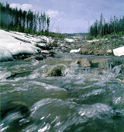 Snow Melt and Stream Flow for the Animas River
Using Math to See How Streamflow is Affected by Snow Melt (Version 2)
The questions that follow will lead you to predicting the monthly streamflow for the Animas River at Durango during the period when the winter snow is melting. We will measure this in cubic feet per month, then convert to cubic feet per second, the most common units used for streamflow in this country.
Below, Table 1 gives average monthly temperatures, in degrees Fahrenheit, for the drainage basin for the Animas River. This was obtained by averaging temperatures at Silverton and Durango.
Table 1
| Month | Jan |
Feb |
Mar |
Apr |
May |
Jun |
Jul |
Aug |
Sep |
Oct |
Nov |
Dec |
Temp |
20 |
24 |
31 |
38 |
47 |
55 |
61 |
60 |
53 |
43 |
30 |
21 |
Question 1: Assume that there is no snow melt during the months when average temperature is freezing or below; during this period, snow accumulates. From the data above, find which months these are. |
The data in the Table 2 below gives the average monthly precipitation, including water from snow, in inches, over the Animas River watershed. This was obtained by averaging precipitation at Silverton and Durango.
Table 2
| Month | Jan |
Feb |
Mar |
Apr |
May |
Jun |
Jul |
Aug |
Sep |
Oct |
Nov |
Dec |
Precip |
1.72 |
1.73 |
2.13 |
1.63 |
1.58 |
1.14 |
2.44 |
2.80 |
2.34 |
2.20 |
1.74 |
1.92 |
Sources: Monthly weather averages for Silverton, CO from Weather.com and Monthly Climate Summary from the Western Regional Climate Center
Question 2: From the data above, compute the total water (in inches) from snow during the months of freezing temperatures. |
Question 3 :Convert your answer to #2 to feet (1 ft = 12 inches). |
Question 4: Follow these steps to estimate the area of the watershed. A) Open Google Earth and enter “Durango CO” in the ‘fly to’ box. B) Place markers at the four corners of the rectangle, using the latitude and longitude given below. To do this, click on the marker icon and then adjust the latitude and longitude as needed. You may need to zoom out and shift north to the place the northern markers. |
Marker |
Latitude |
Longitude |
1 |
37o16’00”N |
107o53’20”W |
2 |
37o16’00”N |
107o37’00”W |
3 |
37o57’00”N |
107o53’20”W |
4 |
37o57’00”N |
107o37’00”W |
Question 4 continued: C) Now select “ruler” under tools. You will use this to measure the sides of the rectangle. Select the “line” tab, and measure in miles. Center the small viewing window as close as possible to the pin of marker 1, click to start your line, move to marker 2, click again to complete it. The measurement will appear. Repeat the process to measure the other sides. Remember that you are only estimating the area, so if your measurements aren’t exactly the same for opposites, take an average. D)Finally, compute the area of the rectangle. This gives you the area of the drainage basin * The answer should be approximately 700 square miles. Use this for the remainder of your computations. |
* Source (The USGS web site Water Watch http://water.usgs.gov/waterwatch/?m=real&r=co shows the actual watershed is 692 square miles. You can check this out by going to the site and locating the dot for Durango in the southwest portion of the state.)
Question 5:What is the area of the watershed in square feet? (Using scientific notation, round to 2 decimal places.) (1 mile = 5,280 feet, so 1 square mile = (5280 ft)2 = 52802 square feet) (Note: if you completed KM Study #1, you already have the answer to this question.) |
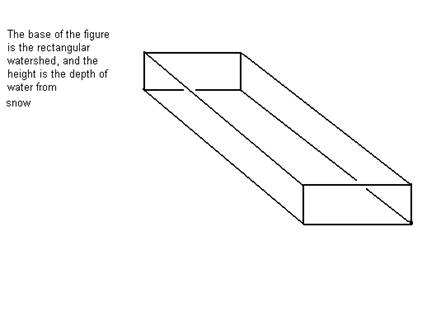
Question 6: Think of the drainage basin as a giant box with a rectangular base with area 700 square miles and height the amount of water from snow over the area (this is you answer to #3). (See figure below.) Now, find the total volume (in cubic feet—use your answer to #5) of water from snow that falls on the watershed during the freezing months. (Volume = Area of Base x Height; Using scientific notation, round to 2 decimal places.) |
Question 7: Assume that it takes 4 months for all the snow to melt after temperatures go above freezing. So, the Animas is getting water from both rain and snow melt during this period. From Table 2, convert the rainfall data to feet for each of the four months of snow melt. (Round to 2 decimal places.) |
Question 8: Use your four answers to #7 and your answer to #5 to compute the volume of rain over the watershed for each of the four months of snow melt. Your four answers will be in cubic feet. (Round to 2 decimal places.) |
Question 9: As temperatures get warmer in the summer months, snow melts faster. Table 3 below gives the percentage of total snow that melts during each of the four months. Now, refer to your answer to #5, and find the volume of snow that melts in each of the four months. Your four answers will be in cubic feet. (Round to 2 decimal places.) |
Table 3
| Month | 1 |
2 |
3 |
4 |
% |
2 |
38 |
56 |
4 |
Question 10: Next, find the total volume of water, rain from #7 + snow melt from #8, over the watershed for each of the four months. (Round to 2 decimal places.) |
Question 11: Assume that only 74% of all water actually reaches the river bed (the rest is evaporated or drawn off for agricultural or domestic use). Find the streamflow for the Animas River for each of the four months of snow melt. (Round to 2 decimal places.) |
Question 12: Convert your answers to #10 to cubic feet per second. (Round to nearest cubic foot.) (1 day = 24 hours, 1 hour = 60 minutes, and 1 minute = 60 seconds) |
Looking back at your answers
1. Review the method you used to find the streamflow.
2. Review the math you used to solve the problems above.
3. Do you think this is an accurate way to predict streamflow during the time of snow melt?
4. How are stream beds and erosion affected during times of high streamflow?
5. How would global warming affect streams, land formation, etc.?
6. Compare your answers to the data presented on the website,
http://pubs.usgs.gov/of/1992/ofr92-129/hcdn92/hcdn/ascii/monthlya/region14/09361500.amm.