Keyah Math Study 1, Level 1
Mathematical Content : Area, Volume, Unit Conversion
Stream Flow for the Animas River 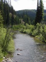
Introduction
This is a study about finding the average amount of water that flows through the Animas River each month. The river has its headwaters above Silverton, Colorado, and flows south to Farmington, New Mexico, where it empties into the San Juan River. This study is concerned with the Upper Animas from its headwaters to Durango. It illustrates (in a simplified way) how scientists can use historic data to predict how much water runs through a stream in a certain time period. This is called streamflow, it can be recorded using various units, for example, in cubic feet per second (cfs), or cubic meters per second or cubic feet per month, etc. Basically, it is measured by volume per time increment. If you measure streamflow at some point on a stream as 500 cfs, this means that 500 cubic feet of water passes through that point every second. For example, the streamflow for the Mississippi River at Baton Rouge is 211,000 cfs whereas the streamflow for the Colorado River below the Laguna Dam (on the Arizona/ California border) is 398 cfs. Geologists are interested in streamflow because it affects amounts of sediment carried by streams (this is somewhat dependent on streamflow) and how this might change stream beds and land formation.
Warm-up Questions
-
How much water do you think flows down a stream near you every day?
-
How could you measure actual streamflow for this stream?
-
Why is it important to predict streamflow for your river or stream?
Using Math to Find the Streamflow for Animas River
The questions that follow will lead you to figuring out the average monthly streamflow for the Animas River at Durango. The first step is to estimate the area of the drainage basin. There are two versions of this module: the first version provides a map of the drainage basin and its approximate area; the second version uses Google Earth and asks you to come up with you own estimate of the area. Click on the appropriate button for each version
Click here for Version Two (Using Google Earth) * click here to download Google Earth