Keyah Math Module 1, Level 1, Version 2
Mathematical Content : Area, Volume, Unit Conversion
Stream flow for the Animas River
Using Math to Find the Streamflow for Animas River (Version 2)
The questions that follow will lead you to figuring out the average monthly streamflow for the Animas River at Durango. We will measure this in cubic feet per month, then convert to cubic feet per second, the most common units used for streamflow in this country.
The first step is to estimate the area of the drainage basin. The actual watershed is irregular in shape but we will estimate the area by a rectangle, using Google Earth. Follow these steps to estimate the area.
1. Open Google Earth and enter “Durango CO” in the ‘fly to’ box.
2. Pace markers at the four corners of the rectangle, using the latitude and longitude given below. To do this, click on the marker icon and then adjust the latitude and longitude as needed. You may need to zoom out and shift north to the place the northern markers.
Marker |
Latitude |
Longitude |
1 |
37o16’00”N |
107o53’20”W |
2 |
37o16’00”N |
107o37’00”W |
3 |
37o57’00”N |
107o53’20”W |
4 |
37o57’00”N |
107o37’00”W |
3. Now select “ruler” under tools. You will use this to measure the sides of the rectangle. Select the “line” tab, and measure in miles. Center the small viewing window as close as possible to the pin of marker 1, click to start your line, move to marker 2, click again to complete it. The measurement will appear. Repeat the process to measure the other sides. Remember that you are only estimating the area, so if your measurements aren’t exactly the same for opposites, take an average.
4. Finally, compute the area of the rectangle. This gives you the area of the drainage basin.
The answer should be approximately 700 square miles. Use this for the remainder of your computations.
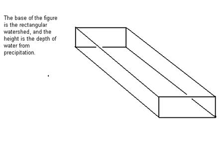
Information you’ll need to answer this question is bulleted below, refer to the figure shown, then answer the question below the figure.
-
The area of the drainage basin, or watershed, for the Animas from source to Durango is roughly 700 square miles.
Source (Note: The USGS web site Water Watch (http://water.usgs.gov/waterwatch/?m=real&r=co) shows the actual watershed is 692 square miles. You can check this out by going to the site and locating the dot for Durango in the southwest portion of the state. More information on the watershed is given in the source listed below
http://www.nmenv.state.nm.us/swqb/Projects/SanJuan/TMDL1/03.pdf
The total average annual precipitation, including water from snow, over this region is 22.17 inches.
Sources (Note: the figure above was obtained by averaging data from the two sources listed below.): Monthly weather averages for Silverton, CO from Weather.com and Monthly Climate Summary from the Western Regional Climate Center
Using math to estimate average streamflow for the Animas River
Question 1: What is the area of the watershed in square feet? (1 mile = 5,280 feet, so 1 square mile = (5280 ft)2 = 52802 square feet) |
Question 2: Convert the annual amount of precipitation from inches to feet. (1 foot = 12 inches) |
Question 3: Think of the drainage basin as a giant bucket with a rectangular base with area 838.2 square miles and height the amount of precipitation over the area, 22.17 inches. (See figure below.) Find the total volume (in cubic feet—use your answers to #1 and 2) of water from rain and snow that falls on the watershed each year. |
| (Volume = Area of Base x Height) |
Question 4: Only 74% of the rain actually reaches the river bed to contribute to its streamflow (all the rest of the water is evaporated or diverted for other uses). What is the annual streamflow for the Animas River? |
Question 5: On the average, how much water flows down the river each month? Each second? (1 year = 365.2 days, 1 day = 24 hours, 1 hour = 60 minutes, and 1 minute = 60 seconds) |
Your answer to # 5 is the average streamflow for the Animas River at Durango; the units should be cubic feet per second, or cfs.
Looking back at your answers
-
Do you think that the methods used here would be accurate for predicting future streamflow?
-
Do you think that you can accurately predict daily, or monthly, streamflow from annual streamflow, particularly for the Animas River? Why?
-
What variations in precipitation might affect monthly streamflow?
-
How would variations in streamflow affect the stream bed, or the land around the stream?
You might refer to the website http://pubs.usgs.gov/of/1992/ofr92-129/hcdn92/hcdn/ascii/monthlya/region14/09361500.amm, average the data given there, and compare to your answers.
Since much of the Animas River watershed lies in the San Juan Mountains at elevations from 8,000 to 14,000 feet, snow and snow melt drastically affects its streamflow. Again, see the website listed above. For a better look at how Animas streamflow is affected by snowfall, go to KM Study #3, “Snowfall and the Animas River Streamflow.”