Keyah Math Module 3, Level 2
Mathematical Content : Area, Volume, Unit Conversion
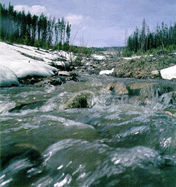 Snow Melt and Stream Flow for the Animas River
Introduction
This is a study about finding the average amount of water that flows through the Animas River during the months of snowmelt. The river has its headwaters above Silverton, Colorado, and flows south to Farmington, New Mexico, where it empties into the San Juan River. This study is concerned with the Upper Animas from its headwaters to Durango. It illustrates (in a simplified way) how scientists can use historic data to predict how snow melt affects the amount of water that runs through a stream in a certain time period. The volume of water that flows through a stream at a designated point in a specified time period is called streamflow, it can be recorded using various units, for example, in cubic feet per second (cfs), or cubic meters per second or cubic feet per month, etc. Basically, it is measured by volume per time increment. If you measure streamflow at some point on a stream as 500 cfs, this means that 500 cubic feet of water passes through that point every second. For example, the streamflow for the Mississippi River at Baton Rouge is 211,000 cfs whereas the streamflow for the Colorado River below the Laguna Dam (on the Arizona/California border) is 398 cfs. In regions where there is a lot of snow, streamflow is influenced in a major way during the time when snow is melting. Indeed, the water available for drinking, household use, or irrigation is dependent on the amount of snowfall the region receives in winter. This is the case for Animas River region since its headwaters and a large part of its path to the San Juan is located in the high San Juan Mountains with elevations from 7,000 to over 14,000 feet. If you completed KM Study #1, “Estimating Average Stream Flow for the Animas River,” you found the average streamflow for a year; however the streamflow significantly fluctuates during the year, particularly during early summer when the mountain snow melts.
Geologists are interested in streamflow because it affects amounts of sediment carried by streams (this is somewhat dependent on streamflow) and how this might change stream beds and land formation.
Warm-up Questions
1. What is the streamflow for a river or stream near you?
2. Does the streamflow vary from time to time?
3. Is this stream fed by snow melt at any time during the year?
4. If so, what time of year and what happens to the stream?
5. Is global warming affecting the amount of rain or snow you get each year?
Using Math to See How Streamflow is Affected by Snow Melt
The questions that follow will lead you to predicting the monthly streamflow for the Animas River at Durango during the period when the winter snow is melting. There are two versions of this module: the first version provides a map of the drainage basin and its approximate area; the second version uses Google Earth and asks you to come up with you own estimate of the area. Click on the appropriate button for each version
Here for Version One
Here for Version Two (using Google Earth) * click here to download Google Earth